
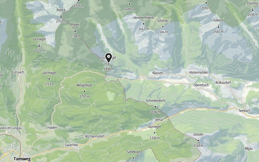
Coordinates
Location of the hut
Decimal Degree - DD: 47.197292°, 13.899632°
Degree Minutes Seconds - DMS: 47° 11' 50.3" N 13° 53' 58.7" E
Universal Transverse Mercator - UTM: 33T 416653 5227676
what3words - w3w: ///his.disappointing.stature
Hiking
Barrier-free path
The Schöckl has been made accessible for everyone! A great route with footbridges in places now enables a tour from the W to the east summit, and the lift and restaurants are also barrier-free.
A new highlight is the mobility park near the transmitter.
Information on
Further information
By bus & train
Hiking with public transport
By public transport via Murau on the Murtalbahn to Murau station. Change to regional bus route 895 towards Krakau and alight at the Krakauschatten-Moos stop; the ascent takes approx. 1½ hours (during the Styrian summer holidays, alight at the Krakau Hintermühlen Klausnerbergsäge stop or at Prebersee and walk up to the Grazer Hütte)
Public transport via Tamsweg: via Unzmarkt on the Murtalbahn or from Salzburg on the Expressbus 270 to Tamsweg station, then take the Lungau Shuttle (book in advance by phone or online) to Prebersee, Tamsweg-Ludlalm stop (2 hours) or Prebersee, then the ascent to the Grazer Hütte; ascent 1½ hours.
- ÖBB timetable enquiry
- DB timetable enquiry
- https://salzburg-verkehr.at/fahrplaene/shuttle/lungau-shuttle/
- ÖBB-Postbus timetable enquiry
Travelling by car: Parking facilities: Preber car park, car park for the ascent to the Grazer Hütte, car park at Klausnerbergsäge (Steirische Krakau)
Access to the hut
Tours in the area
Alpine Club Map 45/3
You can obtain the ÖK Karte from the Grazer Alpenverein at Annenstraße 13
Contact
Hut:
Krakauhintermühlen
8854 Krakaudorf
Mobile: +43 664 762 77 69
E-Mail: info@grazer-huette.at
Tenant:
Anna Wolf & Maik Schneble
W&S Culinary OG
Kirchengasse 4
3375 Krummnußbaum
Opening hours:
28 May to 18 October 2026
Closed on Wednesdays
Hot meals served from 11:00 to 16:00. Before and after these times, a small selection from our menu is available.
Depending on the weather, the start of the season may be slightly delayed; similarly, the hut may close earlier in autumn if it snows.
Weather & tour planning
Das Wetter im Gebirge kann sich schnell ändern und hat entscheidenden Einfluss auf deine Sicherheit und das Bergerlebnis. Eine sorgfältige Wetterplanung ist daher unverzichtbar für jede Bergtour!
Wetterplanung: Vom Großen ins Kleine
Für eine zuverlässige Wettereinschätzung empfehlen wir, zunächst die großräumige Wetterlage zu betrachten und dann zu lokalen Prognosen überzugehen. Folgende Wetterdienste können wir empfehlen:
Alpine Club Weather
- Comprehensible text descriptions of the weather data by Geosphere Austria
- Comprehensive presentation of the general weather situation in the Eastern and Western Alps with important parameters (temperature, zero degree limit, wind, fresh snow)
- Detailed descriptions for individual Alpine regions and mountain groups
- Ideal for an initial overview and basic tour planning
- Updated once a day.
https://www.alpenverein.at/portal/wetter/
Load "external components" for display if necessary.
Meteoblue
- Precise weather information with symbols and probabilities
- Hourly weather forecasts available
- Simple query of point weather via GPS coordinates
- Rain radar for tracking approaching weather fronts
- Particularly useful for short-term and detailed planning
- Frequent updates of the data